The Route
Two options exist for the transportation of Natural Gas through the SAGE Pipeline System:
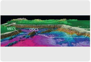
The base case originates in Oman at the Middle East Compression Station (MECS) and ends in India at the Gujarat Pipeline Receiving Terminal (GPRT).
There will also be an Offshore Gas Compression Station (OGCS) about 300km from the Omani coast on top of the Qualhat Seamount (Murray Ridge), which is ~3000meters in height, where the depth of the water is reduced to approximately 400 meters.

Route Option I
Middle East Compression Station to the Gujarat Pipeline Receiving Terminal (MECS—GPRT)
A single uniformly sized pipeline from the Oman coast near Ra’s Al Jifan to the Indian coast at Gujarat
Route Option II

Middle East Compression Station to the Gujarat Pipeline Receiving Terminal via the Offshore Gas Compression Station (MECS—OGCS—GPRT)
A dual sized, single, pipeline from the Oman coast near Ra’s Al Jifan to the Indian coast at Gujarat via a Mid line Re-compression Station situated on the Qualhat Seamount (Murray ridge)
The Qualhat Ridge (Murray Ridge)
The seamounts at the South-West end of the Murray Ridge present a location for an in-line Compression facility, outside of all Territorial Waters but within helicopter supply range

- The Qualhat Ridge is almost 3,000m from the seafloor
- These remarkable features reach to within 300m of Sea Level
- Max Slope 20 deg on Northern side similar to Landfall
- Several examples of platforms in this water depth exist
The Route in Detail
Based on satellite information, a number of route options have been considered. One of them is below –
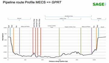
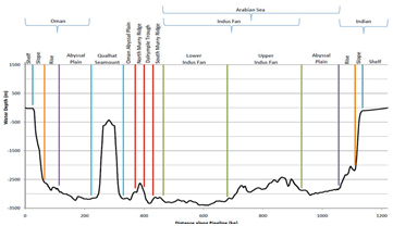
This route initiates at the Middle East Compression Station (MECS) near Ra’s Al Jifan in Oman. The route crosses the Gulf of Oman and the Arabian Sea to terminate at the Gujarat Pipeline Receiving Terminal (GPRT) near Porbandar in India, a total distance of about 1,300km. Approximately 300km along the route is the Qualhat Seamount. This dramatic feature rises almost 3,000m from the seafloor to within 400m of the surface. An option exists to construct an Offshore Gas Compression Station (OGCS) on the Qualhat Seamount.
This route crosses the gently sloping Oman Shelf and then descends the relatively steep and fractured Oman Slope to the Oman Abyssal Plain. The Oman Slope is characterized by a stepping topography caused by faulting and it is incised by deep erosive submarine canyons and channels with steep walls. The Oman Abyssal Plain is generally flat, smooth and featureless. After crossing the Oman Abyssal Plain, the route will ascends the north western slope of the Qualhat Seamount if the option to build the OGCS is selected. The route will either descend the Qualhat Seamount to the seafloor following broadly the same route as for the ascent or descend on a shorter route on the north eastern slope.
On reaching the seafloor, the route turns and passes through a corridor between the Qualhat Seamount and a smaller seamount before crossing the tectonic plate boundary to enter the Arabian Abyssal Plain. The route through the Arabian Abyssal Plain is generally flat, smooth and featureless except where it encounters the meandering channels and levees of the Indus fan. Finally, the route will climb the relatively steep Indian Slope and cross the Indian Shelf to the GPRT.


